Welcome to our Blog!

We hope you will enjoy as we share our journey around this great land!

Tuesday, July 26, 2011

22nd -23 rd July


Up early and heading for the border.  Today is the day we have been looking forward to – entering the Kimberleys.  It is a beautiful morning all though cool for this area and we are on the road by 7:30am.  The road is clear and almost lonely.  It is great to travel at this time although I confess to enjoying the sleep ins too.

Our target is Lake Argyle although we have no guarantee of getting a camp site there, hence our early start.  Ian has so wanted to see the Ord River and the dam and this lake is the one formed by the Ord River Dam.

We were blessed again with a great run down the highway.  About an hour out and we were directed down a side diversion where a bridge was being repaired.  The water truck had just been through and he had done a very, very, very good job.  Mud all over the van.  We stopped for a break just up the road and were told that just after we had gone through a road train had jacknifed his last trailer and closed the road down.  We were glad we had made the early start.
The side road which was closed soon after we passed.
At the WA border we went through quarantine.  No fresh fruit, vegetables or honey area allowed over into WA but Alice had worked it all out perfectly and we were free of stock by this point. 


Just 7 klms into WA and we turned up the road to the dam.  The scenery right along the road this morning was amazing as we passed between  beautiful maintain ranges and escarpments.  The centre of Australia is truly wonderful and it has taken all my life to get to see it.  Our first view of the Ord was a fast flowing stream that we had to cross.  A few cars were parked on the side of the road so we stopped too.  Just metres from the road lay one sleeping crocodile.  They said there a few others too but we were on a mission and had to keep moving.
Imagine a road lined with views like this.

Then to Lake Argyle and we did get a campsite.  Having set up we were ready to explore and I don’t think we were ready for what we were about to see.

This lake is the largest man made lake in Australia.  Yet the dam wall was much shorter than I had imagined.  The wall is built with a black clay core coated in rock.  There is no concrete as this area is on a fault line and earthquakes are a possibility.  Concrete could crack however the clay can flex.  Black clay expands as it absorbs and retains moisture so it becomes impermeable.  The balance of the dam is made up of natural mountain ranges.
Just the start
Below the dam wallfrom the wall.

Water around every corner

What a view from the pool.
It really is a picturesque place and we enjoyed exploring the area.  There are an amazing number of bird species too much to Alice’s delight.  The dam has developed its own unique nature environment.  It is estimated that there are now 24,000 fresh water crocodiles in the lake.  This does not count those in the Ord river below the dam where they estimate there are a further 6000 between the dam and Kununurra.


One night at the dam and we moved on to Kununurra.  This town is claimed to be one of the youngest towns in Australia.  It supported the construction of the Ord Irrigation Scheme and now supports the ongoing agriculture, tourism and the Argyle Diamond Mine.  First top after setting up camp was the supermarket.  The line up of interstate number plates was enormous as all those who crossed the border & quarantine replenished their fruit & vegetable stocks.  Then we checked out the town lagoon, “Lilly Lagoon” where there were some beautiful photo shops available.  In fact over the first two days we were able to visit the local lakes, the large irrigation farming area and also a special gem “Hidden Valley” which is a National Park which borders the town proper.
Hidden Valley - right behind our camp site
Unique formations - Hidden Valley
No landscaper can match God's creation no matter how clever
A hidden gem in a Hidden Valley!

In the farming area we visited a rum distillery producing from local sugar, and also the new Indian Sandalwood outlet.  From Sandalwood they are producing perfumes, health products, toiletries and carvings.  They state that one tonne can produce up to $100,000 in finished product value and apart from India where the trees are being exhausted this is the only other place in the world where the timber is being produced.  The first harvest is due in two years time when the success of the investment will be proved.

In this area we also saw Chia being produced.  This is a plant originating in South America and it produces health foods as a grain.  Again this is a fledgling industry in Australia.  They are also growing horticultural crops, cotton, rice, mangoes, citrus and more.
Irragation, Chia, Sandlewood & mountain background

At end of day two we arrived at Ivanhoe Crossing, a road crossing of the Ord which used to be the main road from Wyndham.  Normally in the dry season high clearance cars can cross the river (about 150m wide) in about 30 – 45 cm depth.  We have seen this crossing in many documentaries.  This year however after the big wet the road has been closed all year and the 60cm high markers cannot be seen.  The river was pouring over the crossing with enormous power and noise.
Ivanhoe Crossing in flood (all year)

This was end of Day 2 in Kununurra and we are here for 7 days.  There is more to come.  Tomorrow we have booked a cruise up the Ord and we are really looking forward to it.  Hope you like too.


Sunday, July 24, 2011

3rd July – 21st July

Well it has been quite a while since we logged an entry in our travel blog so if you have been checking without success we sincerely apologise.

A great deal has been happening though so we have a lot of ground to cover in bringing you up to date.  In our last entry we advised that we were heading back to SEQ to see our family and for us that was a wonderful time. We were blessed greatly in that Merv & Joie Westbrook who are pastors at COC in Darwin and long time friends with Alice offered for us to leave our car & van on the church property at Berrinba not far from the airport.  This was just wonderful for us and Joie graciously dropped us off at the airport for our mid night flight back to Qld.  Isn’t it great to have wonderful friends.

The COC Church in Darwin is an amazing operation.  Even though they are not large in number they operate quite a large hostel for mostly indigenous people who have to travel to Darwin for medical care or other special reasons.  There are people coming in and out continually and it is quite a busy place.  They also have a large interest in overseas missions and financially support over 5000 pastors in many countries in Africa, Asia, Philippines, Indonesia and others.  A lot of the funding for this support is generated by businesses that they have established for just this purpose including a farm and a retail furniture business.  The church is the closest example of a community that I have ever seen. They are a very effective operation.  On return we were able to spend time with them in church and enjoy a Fellowship Tea also.

Back in Queensland we were able to spend time with Ian’s father through a few visits as well as time with each of our family with the exception of Joy & Luke in Chinchilla.  Unfortunately & disappointingly it was not possible to make it out there.  However the time we spent with those who we could meet was just so wonderful.  We had been really missing them so this quality time, particularly with our grandchildren was very special.

All good things must come to an end however and we made our way back to Darwin on the 15th of July.  Apart from the necessary time needed to restock and complete some van repairs (it is showing its age) we were able to see some more of Darwin.  In particular we did enjoy some time at Casuarina Reserve which is a beach area to the north edge of Darwin.  Here the beach is edged by some spectacular, though not too high stone cliffs. 
The cliffs of East Point Darwin
Darwin CBD from East Point

Ian also spent some time visiting the Aviation Museum where there were some interesting aircraft on display.  The pride of the museum is the large B52 bomber.  It totally filled the hanger building and all other aircraft sat under her wings.  She really did look like mother hen.  Some may not know that the B52 has not been long retired from the US Air force but is probably best known for long range bombing raids into Vietnam during the war there.  It is powered by six jet engines.  Coincidently the US Air force is here with the Australians and playing war games so each morning the F18s noisily take off from Darwin airport across the city.  I understand that they are linking up with exercises in Central Queensland.  Shows how small the world is.
B52 Bomber fills the hanger

Aus Mirage fighter - retired but still looking up to date

On Tuesday 19th we left Darwin heading for West Australia.  Our first intended stop was to be Edith Falls some 60 klms north of Katherine however on arrival we found the “Full House” signs out.  We had been amazed all day with the number of caravans heading north to Darwin and we were to find out soon after that this was just to be the start.  The flood gates have certainly opened and it is getting very difficult to find accommodation.  Even the few free stops along the road are full and some are choosing to pull up anywhere they can, legal or not.

Edith falls is part of Nitmiluk National Park which includes Katherine Gorge as it main feature.  The falls are more like cascades and while they are beautiful visually they are more appreciated by visitors as a cooling off swimming opportunity.  Seeing that it is still school holidays here the camp ground was really full and no one was rushing to move out either.
Edith Falls
More a holiday camp than a visitors view

We spent the night in Katherine and then on again next morning.  The road west to the border is again quite flat.  The country is quite similar to what we have seen right through NT but as we drew closer to Victoria River Roadhouse (approx 200klms) the road followed a path leading between some tall red rock ranges.  These were quite spectacular.  Then we dropped down to cross the Victoria River and the roadhouse, located on the western bank looked like an emerald green oasis in a red dirt landscape.  There are only two fuel stops in over 500 klms from Katherine to Kununurra and this was the first so there were a lot of travellers stopped to refuel vehicles and occupants.

The Victoria River is the largest river in the Northern Territory and the road runs quite close to it (although not always in sight) from Victoria River Roadhouse to a point west of Timber Creek. Because we were unsure of where we could stop that night and we had still a way to go we did not spend a lot of time here.  The roadhouse we had heard from past years was not a great stop but the signs said “Under New Managers Wife” and there were beautiful green lawns, great camping areas and good facilities on offer.  The wife must know how to pull some strings.
Crossing the Victoria River near the roadhouse

On further we travelled and arrived at Timber Creek about lunch time.  This is the other fuel stop and here we actually found it was a little more than a roadhouse.  Here we booked into a small park which was quite cheap and after checking it out quickly extended our booking for a second night.  This is a very relaxing stop and plenty to see.

Coming into Timber Creek we saw our first Boab tree.  Apart from a transplant in Perth Botanical Gardens we have only seen photos of these amazing trees but here is their real home.  We are yet to learn all about these trees but the first thing we learnt was that they can heal themselves when scarred in any way.  In two places in WA they were hollowed out as early jails and they healed over the new carved surfaces.
The Boab tree is a feature of the Kimberleys

We took a sunset cruise down the Victoria River.  We were picked up at our camp in an old 1971 bus similar to school buses we remember.  We then received a commentary of the history of Timber Creek as we travelled out to the boat approx 10 klms.  Timber Creek received it’s name from the explorer / surveyor Gregory who had holed his boat at the mouth of the Victoria River and set out looking for suitable repair material.  In  small tributary he found paper bark trees which he chose for his repair.  Therefore he called it Timber Creek.  The story goes on in depth but he soon found out that paper bark was not a good repair material.  The National Park surrounding the town is called Gregory National Park.  We boarded the boat in Big Horse Creek.  We were told that large Barramundi are often called “big Horse” and they catch a few there.  Then we set out down the Victoria River at great speed.  The river was quite wide and they experience eight metre tides at the mouth so it varies in depth quite significantly.  We saw some crocs both freshwater & salties, small rock wallabys and lots of birds.  The banks were very green, more than we have been seeing lately.  Some 25 klms down stream we came to a pontoon where we stopped for refreshments.  The skipped threw a line over the side and soon a catfish was caught.  He then placed it on the frame of the pontoon and called in a large Sea Eagle who swooped right onto the pontoon to take the catch.  Then it was back up the river and as the sunset we had the chance of seeing the changing colours over the distant ranges and the river.  Quite an experience!
Victoria River at Timber Creek


Birdlife from the river


Taking a rest in the park!


And not another human in miles (except on the boat)

A sea eagle taking a fish off the pontoon

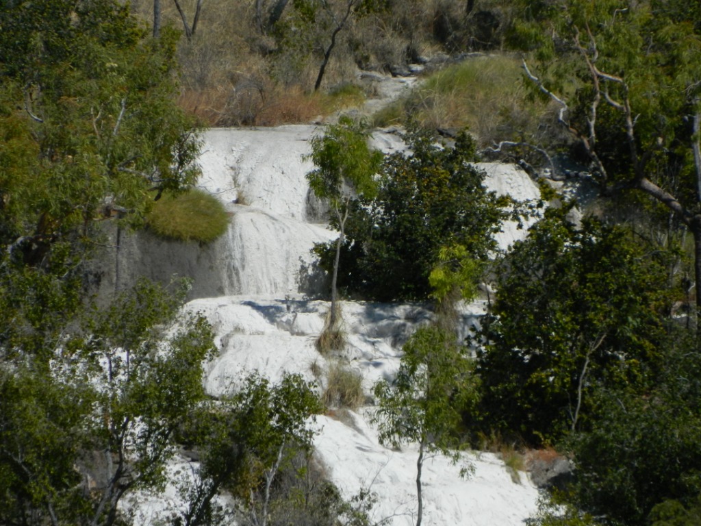
Next day we explored the Gregory National Park and visited a Limestone Gorge.   We travelled about 60 klms down a dirt road and disappointingly we discovered when we got there that most of the gorge was closed.  We did however see a unique Calcite Flow.  This was a vivid white staining of a dried up water fall where the water has had a chemical reaction with the dolomite rock leaving a white limey crust or stain.  It looked like snow from the distance.  The geology of the whole gorge area was quite interesting.  Nearby were small ponds formed by a dense cement time material which they called Tuffa. 

Tuffa Ponds with a Croodile tree in foreground. 
Can you see why it is called Crocodile tree?


A Caltite Flow over a water fall which is dry at the time.

The dolomite rock of the area is weathered in a unique form.

Back in the town we checked out the local lookouts and obtained some great views of the river.  There were caravans parked in every available spot legal or illegal and we found the latter very dishonouring for the locals.

Timber Creek was only planned as an overnight stop but has been a pleasant & restful layover.  As almost always the people we have met here are so interesting.  On the road there are no levels of status or barriers between people and backgrounds or employment history are seldom discussed.  It is all about what we have seen or where we are going, and of course the grandkids. 

Caravaners on the road can be likened to people who have alziemers.  We meet new friends everyday.
Tomorrow we are heading over the border and into our sixth state / territory.  We are really looking forward to that


Sunday, July 3, 2011

27th – 2nd July


A few days have gone by and we have not recorded our activities.  Today we are relaxing at a small camp just outside Litchfield National Park and catching up on all the things not yet done.

As for the whole of our journey the last week or so has not gone exactly as we had envisaged.  You will note that I did not use the word “Plan” as it is no longer a regularly used word in our vocabulary.

We arrived in Darwin (actually staying at Howard Springs – 23 klms south of Darwin) on Monday.  The journey from Kakadu took us through more of the park and especially some wetlands however as we had made a commitment in Darwin we did not stop much.  In our experience wet lands need to be visited in early morning or late afternoon to see the wildlife and visits in the mid day do not give a real picture of the area.

In Darwin we caught up with all of the vans we had seen travelling up through the centre.  The population here swells significantly during winter (they call it the dry season here) and there are an enormous number of vanners who migrate north for the winter and just sit in the parks.  They become a community of their own.  Surrounding us we had some Victorians who were doing some short term work (2 months), a couple from Harvey Bay (3 months), and some Jews from Melbourne there for 12 weeks and an elderly couple form Victoria who have been coming here for years every winter.  And that is just a sample. 
We did not do a lot of tourist things in Darwin.  We did however meet up with some wonderful friends of Alice and they have been great hosts to us. 

 The 1st July is Territory Day in the NT.  It is the anniversary of the establishment of self government for the territory.  To celebrate the aw allows fire crackers to be sold and set off for this one day only.  The sales can only be made on the day and they all have to be exploded on that night before 11:30pm.  Any activities, sales or use outside these hours draws prosecution.  It is fairly unique for Australia by our experience.  The population goes crazy too.  It goes unsaid that emergency services also go crazy trying to deal with the outcome with some injuries and over 200 calls outs for fire over night.  One rocket landed within one metre of our car and van, luckily without any significant damage.

From Darwin we moved on to Litchfield NP and enjoyed some good walks in the heat.  Litchfield is approx 130 klms from Darwin and for most people it is a day trip.  There are many rocky water holes and some are free for swimming so the crowds turn up just for that purpose.  As for the rest of the Top End there are many visitor sites that have not been reopened after the big wet they experienced earlier in the year.

We continue to be surprised by the sparseness of the population here in the north.  The shire bordering the NP has a population of just 1647 people and it covers quite an area.  It is difficult to image how a shire can operate economically.
Florence Falls

 The country here is quite open typical NT bush.  The Park starts in the flat planes and rises to a table top plateau.  It is known for its waterfalls some of which flow all year round.  This is because the flat table top has weathered significantly creating large crevices in which have grown vegetation.  These crevices become large sponges in the wet season then slowly leak out over the whole year.  The water is crystal clear which is great for swimming however the clear water does not always encourage water wildlife to abound.
Buley Rock Pools
Very few cameras - lots of swimmers
Florence Falls - they swim in the pool here too!
The main attraction in the park is Wangi Falls.  These are beautiful (twin) falls which flow all year round.  When we were there the pool below the falls was closed because of crocs.  The water is so clear that one would have thought you would see them coming but apparently not.  The parklands surrounding were well laid out and it was a prime spot for coach tours to have lunch.
Wangi Falls.  Crocs in this pool
Tolmer Falls - surrounding area is a sacred site
Pool below Tolmer - note the clear water from 60 m away
The stream feeding the falls - Tolmer

A unique resident of the park is the Magnetic Termite.  It builds scores of termite mounds and in many cases they form a structure wafer thin that lies in a north / south direction, hence the name Magnetic.  In fact they are not actually magnetic.  This breed of termite does not burrow below ground so it lives totally above ground.  In this climate the mound he builds can become extremely hot from the sun.  To manage this the termite tries to build a constant thickness in its mound.  In the morning the termite them migrates to the western side of the mound where it is cooler but as the day progresses and the sun moves to the west he needs to move to the eastern side to maintain a constant temperature.  Hence his answer is to build a mound of near constant thickness in a north south direction.  Maybe we should consider that in our home construction.
Giant Termite mounds - approx 4 m high
Wafer thin Magnetic Termite Mounds
See the scores of mounds behind trees and ferns
Tabletop Swamp

We hope you enjoy some of the photos here.  We must say that although Litchfield is really beautiful it has not come up to our expectation.  I think this is more an issue of our expectation having been built too high as compared to actual.  The country is quite dry but interlaced with some beautiful little oasis mostly along stream courses.  It has really been worthwhile coming here though.  Hope you enjoy.

 From here the news is that we are travelling back to SEQ for family reasons.  We will be away for about 10 days giving us an opportunity to spend time with each of our family.  We know this will be all too short but they are very special and we miss them all.